


Has the Drone Killed Travel and Landscape Photography?

The drone is probably one of the tools that has most profoundly transformed travel and landscape photography in recent years. With relatively compact equipment, it now gives a large number of photographers access to a viewpoint that was once much more difficult and expensive to obtain. From both an economic and environmental perspective, the advantages are obvious, but this democratisation has also had a less frequently discussed consequence: it has made the aerial view commonplace.
For a long time, this rarity gave images made from the air a particular strength, sometimes making the viewpoint itself an instantly recognisable visual signature, as in Yann Arthus-Bertrand's Earth from Above. The drone has profoundly changed our relationship with this type of image: what was once exceptional has gradually become familiar.
My work as a photographer gave me several opportunities to fly in helicopters while on assignment. This photograph, taken in Chad during the 1992 Paris-Le Cap Rally, clearly shows the documentary value an aerial view could provide. From ground level, the view would have been limited to a few dwellings or part of the village; from the air, its organisation becomes immediately apparent, along with the paths used between the huts and the contrast between the tall grass and the cleared or burned areas surrounding the dwellings.
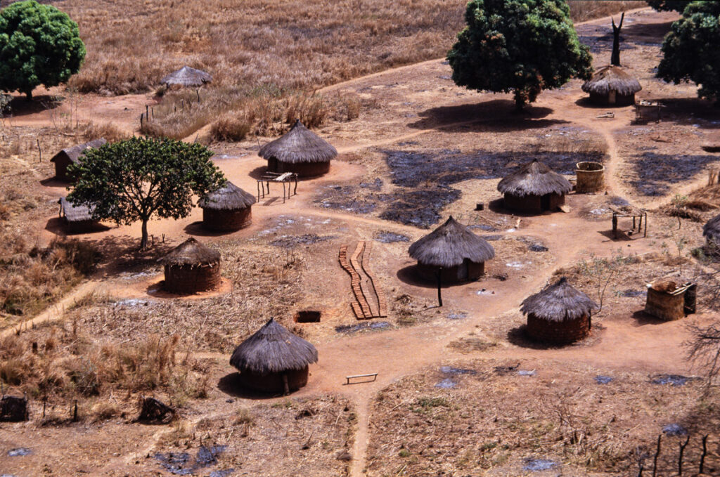 Village in Chad photographed from a helicopter during the 1992 Paris-Le Cap Rally - Photo: © Sebastien Desnoulez
Height therefore does more than make an image more spectacular: it can reveal information that a ground-level viewpoint cannot always convey. In this case, the photograph was made possible by the particular circumstances of the assignment. A drone now provides much easier access to this way of reading a landscape and a territory.
The drone magnifies the landscape
There is no denying one of the drone's greatest strengths: it is extraordinarily effective at revealing a territory. In travel photography, on the websites of tourist boards, tour operators or travel bloggers, an aerial view can immediately show a place as a whole. A monument appears within its surroundings, a beach becomes a graphic interplay between sand and transparent water, and a mountain road suddenly reveals the pattern of its bends. A cliff, reef, field, forest or geological feature takes on a dimension that is impossible to perceive from ground level.
The drone does not simply show the landscape: it organises it. It removes certain unattractive details, reduces the visual presence of street furniture, car parks or surrounding buildings, and turns the territory into a graphic composition. An ordinary road becomes a line, a beach a coloured surface, a group of rocks an abstraction. This is also why aerial images have become so effective in tourism communication: they instantly provide a spectacular overall view, although that effectiveness also has a downside.
When the real landscape seems less spectacular than the image
A beach can look magnificent from a hundred metres above and much more ordinary when photographed with your feet in the sand. From the air, the transparency of the water, variations in depth and the geometry of the shoreline create an image that simply does not exist from ground level.
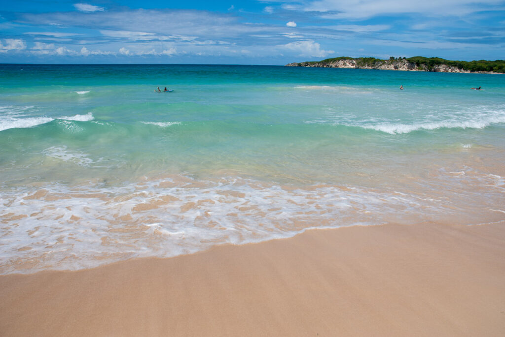 Playa Macao, Dominican Republic - Photo: © Sebastien Desnoulez
A concrete example is Playa Macao, near Punta Cana in the Dominican Republic. From the beach, the place is beautiful, with its pale sand, turquoise water and the headland closing off part of the horizon, but a conventional photograph from the shoreline struggles to convey the shapes and variations in colour that an aerial view would reveal.

Freelensing at Playa Macao, Dominican Republic - Photo: © Sebastien Desnoulez
Without a drone, I chose to approach the place differently. A second photograph made using freelensing deliberately limits sharpness to part of the breaking wave and transforms the landscape into a succession of textures and colours. The result no longer tries to describe Playa Macao as a whole: it offers a different interpretation of the same place.
This gap does not only affect photographers. The images used by tourist boards, tour operators, travel blogs or social media also help construct an idealised representation of destinations. The aerial view naturally selects what gives a place its visual strength, while making much of what visitors will actually encounter on the ground disappear: traffic, car parks, tourist infrastructure, shops, queues or the sheer density of visitors.
The Cinque Terre or some of the villages along the Amalfi Coast are good examples. Seen from a distance or from the air, the accumulation of brightly coloured houses on the slopes and along the Mediterranean creates a spectacular image that may be enough to inspire the desire to travel. The experience at ground level can be very different: crowded stairways and narrow streets, heavy flows of visitors, souvenir shops and restaurants then occupy a space that the overall view did not reveal. The image is not misleading, but it tells only part of the story.
The drone therefore has a particular ability to magnify a landscape while simplifying its reality. By gaining height, it turns a complex territory into a composition and can create, for travellers and photographers alike, expectations that the experience on the ground will not always be able to fulfil. For photographers without a drone, the frustration can be even greater when the image that attracted them is not simply based on a better viewpoint they need to find, but on a position that simply does not exist for someone photographing on foot.
The drone also changes our relationship with time
The drone does not only transform the viewpoint; it also considerably changes the time required to obtain it. Take Venice: a photographer working on foot can search for elevated viewpoints by climbing campaniles, reaching terraces or visiting accessible church domes. Every move takes time; opening hours have to be considered, the city has to be crossed, and it may be necessary to return on several evenings to photograph different viewpoints under comparable light.
A photographer with a drone and the necessary authorisations does not work under the same constraints. In a single late afternoon, the viewpoint can be moved by several hundred metres, the altitude varied and the angle changed, making it possible to produce at sunset several views that might have required four evenings for a photographer working exclusively from the ground.
The drone can therefore considerably compress the time devoted to photographic scouting. Where a photographer once had to physically reach an elevated position, a drone pilot can move the camera through three dimensions and explore an entire volume around the subject in just a few minutes. This obviously does not mean that drone photography requires no skill: the pilot must fly the aircraft, anticipate composition on a screen and take account of wind, battery life, light, flight restrictions and safety rules. Part of the difficulty has simply shifted: reaching the viewpoint is no longer necessarily the main obstacle, and the question becomes which of all the viewpoints now available actually deserves to become a photograph.
A new freedom that also creates new clichés
This is where a paradox appears: the drone provides access to more viewpoints than ever before, yet this freedom sometimes produces images that increasingly resemble one another. Winding roads photographed vertically, tiny swimmers in turquoise water, cars lost in vast landscapes, boats leaving white wakes behind them, beaches photographed straight down, ridgelines and graphic shadows: these images were spectacular when they were rare and have now become familiar.
As with reflections in puddles, long exposures or certain colour grades popularised on Instagram, the effect eventually becomes a convention. The drone may not have killed landscape photography, but it has undoubtedly contributed to the disappearance of the rarity of the aerial view. The problem is obviously not the tool itself: excellent photographs can be made with a drone, but access to a spectacular viewpoint is no longer enough, by itself, to produce an original image.
Not owning a drone does not necessarily mean rejecting progress
It would be too simplistic to oppose photographers who use drones to those supposedly tied to a more traditional approach. Not photographing with a drone does not necessarily mean refusing to change one's habits, nor does it automatically reflect nostalgia for the photographic rules of the past. The choice can be much more pragmatic.
A drone represents an additional expense, along with batteries, a charger and accessories. For a photographer who already travels with one or two camera bodies, several lenses, filters, perhaps a tripod and a computer, every additional piece of equipment has to fit into a bag that quickly becomes heavy and cumbersome. The issue becomes even more significant when travelling by air, where cabin baggage weight and size limits already require compromises, while lithium batteries bring their own transport restrictions.
There is also a regulatory framework that can seem complex to someone who only wants to use a drone occasionally: flight categories, possible training requirements, prohibited or restricted areas, rules that vary from one country to another, and checks that need to be made before each flight. Some users unfortunately choose to ignore these constraints and fly their drones where they are not permitted, while photographers who want to respect the rules must incorporate this additional preparation into their travels. It is therefore not necessarily a question of one generation of photographers refusing a new tool, but often a simple trade-off between the expected photographic benefit and the additional constraints it brings.
48 megapixels do not mean 48 megapixels of detail
The compromise also concerns image quality. An ultralight drone such as the DJI Mini 4 Pro is remarkably capable considering its weight. At under 250 g, it produces files advertised at up to 48 megapixels and offers image quality that is more than sufficient for social media, the Web and many editorial uses.
On paper, 48 megapixels also appear sufficient for large prints, but pixel count alone does not determine the actual quality of an image. A small sensor containing tens of millions of photosites does not provide the same richness as a full-frame sensor with a comparable pixel count. Sensor size, photosite size, optical quality, dynamic range, noise and digital processing all have a direct impact on the amount of detail that is genuinely recorded.
Experience with smartphones illustrates this perfectly. A phone equipped with a 50-megapixel sensor can produce an impressive-looking image on its screen and allow substantial zooming, but when the file is viewed at 100% on a large monitor, smoothed textures, reconstructed details and areas that quickly turn into a mush of pixels often become apparent. The pixels are present in the file, but they do not necessarily represent the same amount of independent photographic information.
The same caution applies to the small sensors used in drones. Two files containing 45 or 48 megapixels may have almost identical pixel dimensions while containing very different amounts of genuinely usable detail. For a book, a good file made under favourable conditions may be perfectly suitable; for a 40 × 60 cm print intended to be viewed closely, more caution is required, especially with subjects containing fine detail such as foliage, architecture or certain terrain textures.
This creates an interesting paradox: the drone may provide the most spectacular viewpoint of the entire trip while producing the technically least detailed file of the assignment.
What is left for the photographer without a drone?
The question is probably not how to compete with an aerial photograph when working from the ground, because that is not always possible. It may be more interesting to look for something else: move closer to the landscape rather than trying to encompass it as a whole, work with details, textures, light, human presence, architecture or relationships between different elements, find a viewpoint accessible on foot and accept that a place can be photographed without necessarily showing it in its entirety.
The drone is particularly effective at describing the geography of a place, but travel photography does not have to be purely descriptive. It can also suggest, isolate, tell a story, fragment or concentrate on details that precisely escape the global view. For the photographer without a drone, what might initially appear to be a disadvantage can therefore become an aesthetic choice: leave the overall view to aerial images and try instead to tell the story of a place from within.
This may even be one possible response to the growing familiarity of aerial photography. For a long time, the difficulty was finding a different viewpoint; today, drones allow many photographers to reach very similar positions in the sky. The question is therefore no longer simply how to gain access to a spectacular angle, but rather how to determine, among all the viewpoints that are technically possible, which one genuinely reflects a personal way of seeing.
The drone has therefore not killed travel or landscape photography, but it has profoundly changed the rules of the game. As often happens when technology democratises something that was once difficult, expensive or rare, the difference is no longer simply about gaining access to a viewpoint: it shifts towards the way a photographer sees, selects and interprets a place.
About the author
Sebastien Desnoulez is a photographer, author and image maker based in Paris. His work spans architectural photography, landscape photography and travel photography, with particular attention to composition, lines, light, blur and visual accidents. Trained in photography in the mid-1980s, he covered Formula 1 and reported from around the world before developing a fine art photography practice built around the tension between graphic rigour and visual instability. He also shares his technical experience through practical articles for passionate photographers, drawing on a strong visual culture acquired in both film and digital photography.
Tags